AlphaEarth Foundations
An Earth observation foundation model that turns massive, multimodal satellite and geospatial data into compact annual embeddings for global mapping and monitoring.

What It Is
AlphaEarth Foundations functions like a virtual satellite. It characterizes terrestrial land and coastal waters by combining diverse Earth observation streams into one model-ready representation.
Core Output
The model produces 64-dimensional embedding fields that summarize a location through time. Annual embeddings are available in Google Earth Engine as the Satellite Embedding dataset.
Primary Uses
It supports ecosystem classification, agricultural monitoring, deforestation analysis, urban expansion tracking, surface property estimation, and water resource assessment.
Why It Matters
A consistent view of a changing planet
Satellites capture information-rich imagery and measurements every day, but the data is complex, multimodal, and refreshed at high frequency. AlphaEarth Foundations is designed to connect those disparate signals so analysts can work from a more complete and consistent picture of Earth.
DeepMind frames the model as useful for decisions around food security, ecosystem change, deforestation, urban growth, and water resources.
Visuals
Embedding views from the DeepMind article


How It Works
A compact representation built from many sources
AlphaEarth Foundations combines public data sources such as optical satellite imagery, radar, 3D laser mapping, and climate simulation outputs. It then produces a compact summary that can be used for downstream mapping and monitoring tasks.
DeepMind reports that this compact representation reduces storage requirements and makes planetary-scale analysis more practical.
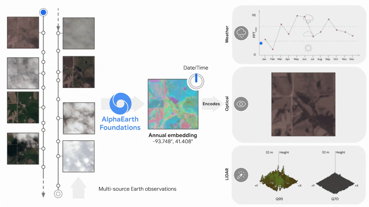
Representation
Global embedding fields
Each embedding has 64 components. DeepMind describes the result as a global embedding field that can be queried and used by mapping systems in Earth Engine.

Dataset
Satellite Embedding dataset in Earth Engine
The annual Satellite Embedding dataset is available through Google Earth Engine. It contains more than 1.4 trillion embedding footprints per year and is intended to help researchers and organizations build custom maps more quickly.